

SLINK
Custom GIS Automation Software for Australian Volume Housing Industry
Project overview and goals
About the client
- Project: GIS construction software
- Industry: Volume Housing Industry
- Region: Australia
- Technologies: C#, ASP.Net Core, WPF, Azure DevOps, LandXML
- Duration: 2021-2023
SLINK began as an MVP to automate core surveying tasks in Australian volume housing. Initially it stemmed from the "Survey Automation" concept, but it quickly evolved into a fully functional prototype for Intrax, one of Australia's leading surveying and geospatial firms. This centralized data, automated traverse calculations and boundary validations, and enabled real-time synchronization between field and office teams.
The main goal was to prove the concept: replace fragmented manual workflows with a unified, accurate tool. Therefore, we prioritized speed — delivering a prototype fast enough for real-world testing, validation, and production deployment.
The main goal was to prove the concept: replace fragmented manual workflows with a unified, accurate tool. Therefore, we prioritized speed — delivering a prototype fast enough for real-world testing, validation, and production deployment.
Services Used
THE CHALLENGE
Australian volume housing surveying relied on manual, disjointed processes:
- Time-consuming manual traverse calculations and boundary checks per lot.
- Data moved manually between field notes, Excel, and CAD — prone to errors, inconsistencies, and rework.
- Resulting delays (often 1–2 weeks per site), compliance risks, and higher costs in high-volume developments.
The client needed a quick-to-build MVP that could automate core tasks, centralize data, and demonstrate real efficiency gains — without over-engineering.
THE SOLUTION
SLINK MVP — a focused desktop + cloud prototype built by 24Gen:
- Desktop app: WPF with Eyeshot CAD for interactive drawing canvas (zoom, pan, snap, layers for easements, structures, survey points).
- Backend: ASP.NET Core APIs + SQL Server for centralized cadastral/lot/structural data.
- Core automation: Traverse processing, boundary validations, real-time field-to-office synchronization.
- Interoperability: Seamless import/export via LandXML, DXF, CSV — no painful conversions.
- Usability & security: Role-based access, Microsoft SSO, built-in validation rules to catch errors early.
Developed agile in bi-weekly sprints (2021–2023) with emphasis on rapid iteration, surveyor usability, and quick MVP deployment/validation.
THE BENEFITS
As an MVP, SLINK proved its value in production:
- Significantly reduced manual effort on traverse and validation tasks.
- Cut down errors through automated checks and real-time sync — less rework on site.
- Enabled faster, more reliable data delivery from field to construction teams.
- Successfully deployed end of 2023 and remained operational in the Australian volume housing market.
- Demonstrated scalability and integration potential for full-scale rollout.
The MVP met core expectations, showed strong real-world performance, and validated the approach for streamlining high-volume surveying workflows.
The Need
In the Australian volume housing sector, surveyors and engineers face intense pressure to process high volumes of lots quickly and accurately. Traditional workflows rely on manual, fragmented tools: field notes jotted on paper or devices, data transferred via Excel spreadsheets, and final boundary validations and traverse adjustments performed in standalone CAD software.
This disjointed approach creates multiple pain points:
This disjointed approach creates multiple pain points:
- Repetitive manual computations — traverse calculations, boundary checks, and structural layouts consume hours per lot, with no automation to handle repetitive patterns across large developments.
- Data silos and transfer errors — information moves manually between field teams, office engineers, and construction planners, leading to copy-paste mistakes, version inconsistencies, and frequent rework when discrepancies surface during compliance checks or on-site.
- Delays cascading through the pipeline — a single inaccurate dataset can delay approvals, hold up construction starts, or trigger costly site rework, often adding 1–2 weeks per site in high-volume projects where timelines are tight.
- Compliance and cost risks — manual processes increase the chance of boundary errors or non-conformance with cadastral standards, exposing developers to regulatory penalties, disputes, or expensive corrections.
The client required a purpose-built MVP solution that could rapidly automate core surveying tasks, centralize data in a reliable cloud-backed system, enable real-time synchronization between field and office, and integrate seamlessly with industry formats (LandXML, DXF, CSV) — all without excessive complexity or long development cycles. The goal was to prove that targeted automation could deliver measurable efficiency gains, reduce human error, and support scalable operations in the demanding volume housing market.

The Solution
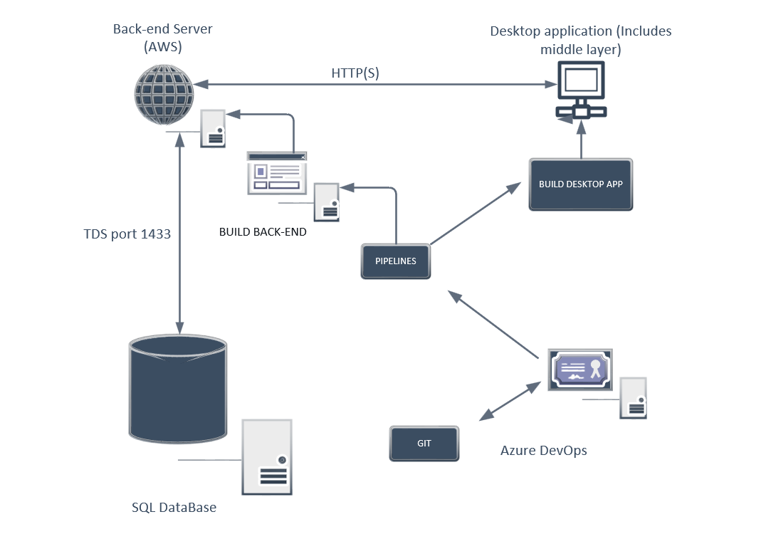
SLINK MVP was designed as a modular, purpose-built prototype combining a powerful desktop client with a secure cloud backend to automate and centralize surveying workflows in Australian volume housing.
Core Components and Architecture:
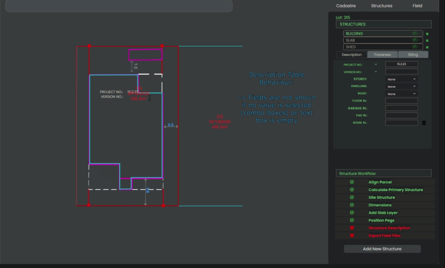
Core Components and ArchitectureThe SLINK MVP combines a powerful desktop client with a secure cloud backend. This approach automates surveying workflows effectively. For example, the desktop application uses WPF with Eyeshot CAD integration. Additionally, it provides an interactive drawing canvas. Users can zoom, pan, snap, and manage layers for easements, structures, and survey points. As a result, visual editing of cadastral plans becomes much faster.
Moreover, the backend relies on ASP.NET Core REST APIs. It handles business logic, data validation, and synchronization. Furthermore, the system communicates securely via HTTPS. Therefore, field-to-office data flow works in real time without interruptions.
Consequently, the centralized SQL Server database stores all cadastral data reliably. In addition, it supports role-based access and audit trails. Ultimately, this modular setup enables quick prototyping of core features like traverse processing and boundary validations.
Core Components and Architecture:
Core Components and ArchitectureThe SLINK MVP combines a powerful desktop client with a secure cloud backend. This approach automates surveying workflows effectively. For example, the desktop application uses WPF with Eyeshot CAD integration. Additionally, it provides an interactive drawing canvas. Users can zoom, pan, snap, and manage layers for easements, structures, and survey points. As a result, visual editing of cadastral plans becomes much faster.
Moreover, the backend relies on ASP.NET Core REST APIs. It handles business logic, data validation, and synchronization. Furthermore, the system communicates securely via HTTPS. Therefore, field-to-office data flow works in real time without interruptions.
Consequently, the centralized SQL Server database stores all cadastral data reliably. In addition, it supports role-based access and audit trails. Ultimately, this modular setup enables quick prototyping of core features like traverse processing and boundary validations.
Development Process
The MVP was delivered using agile methodology in bi-weekly sprints over 2021–2023. We used Azure DevOps for project management (Boards, Repos, Pipelines), Git for version control, and automated CI/CD pipelines for building the desktop app and backend. Testing combined automated unit/integration tests with manual QA focused on surveyor usability.This architecture allowed rapid prototyping of core features (traverse automation, real-time sync, boundary checks) while keeping the scope tight for MVP validation.
The result was a deployable prototype that proved the concept without unnecessary complexity.
The MVP was delivered using agile methodology in bi-weekly sprints over 2021–2023. We used Azure DevOps for project management (Boards, Repos, Pipelines), Git for version control, and automated CI/CD pipelines for building the desktop app and backend. Testing combined automated unit/integration tests with manual QA focused on surveyor usability.This architecture allowed rapid prototyping of core features (traverse automation, real-time sync, boundary checks) while keeping the scope tight for MVP validation.
The result was a deployable prototype that proved the concept without unnecessary complexity.
Interested in a custom MVP for your GIS, CAD, or automation needs? Contact us
The Benefits
SLINK MVP proved its value in production.
- Firstly, it significantly reduced manual effort on traverse and validation tasks. For example, surveyors no longer spend hours on repetitive calculations. As a result, they focus on analysis instead.
- Secondly, built-in checks and real-time sync cut down errors. This means fewer inconsistencies and less rework on site. Moreover, compliance risks dropped noticeably.
- Furthermore, faster data delivery helped construction teams. Consequently, projects moved ahead without long delays. In addition, collaboration improved thanks to role-based access and Microsoft SSO.
- Ultimately, the MVP demonstrated scalability. Therefore, it showed strong potential for full-scale rollout in high-volume housing.
As an MVP, SLINK exceeded expectations by transforming fragmented manual processes into a streamlined, accurate system — proving that targeted automation could deliver efficiency gains, cost savings, and better project outcomes in a demanding niche industry.
The Result
SLINK MVP was successfully deployed by the end of 2023 and has remained operational in the Australian volume housing surveying market ever since. As a focused prototype, it achieved its primary objectives: automating key repetitive tasks, centralizing data, and enabling real-time collaboration between field and office teams.
Key outcomes include:
Key outcomes include:
- The platform demonstrated strong real-world performance under actual project workloads, handling cadastral data processing, traverse calculations, and boundary validations reliably.
- It met the core expectations of the client by delivering a usable, integrated tool that reduced manual friction and improved data accuracy without requiring a full-scale enterprise overhaul.
- The MVP validated the overall approach: targeted automation via WPF/Eyeshot desktop + cloud backend + industry-standard formats (LandXML/DXF/CSV) can significantly streamline high-volume surveying workflows.
- It laid a solid foundation for potential future iterations, proving scalability, integration capabilities, and production readiness in a niche, demanding industry.
Overall, the project showcased 24Gen's expertise in building effective MVPs for specialized GIS/CAD automation — turning a clear industry pain point into a working, deployed solution that continues to support operational efficiency.
SEE MORE OUR CASE STUDIES
Contact us
Please fill out the form, and we will get back to you once your request has been processed.
You can also send your request directly to our email: info@24gen.space
We will respond as soon as possible after receiving your message.